


Shadow of the Rockies
Continental Divide Run -2011
Shadow of the Rockies
Continental Divide Run -2011
"Shadow of the Rockies"
Expectations normally and unnecessarily define how we enjoy so much of our lives. How we expect our relationships to mature, how successful our work becomes, and unspoken expectations about our journeys can be unfortunate drivers of the experience of life. The Continental Divide Run that the Flatwater Overland crew embarked upon in the fall of 2011 was no different. Shadow of the Rockies was a journey of unprecedented magnitude for us, and took roughly two years to plan and prepare for. To compound this anticipation, two of us were coming directly off of a military deployment to Afghanistan and needing some down time. To say everyone on the crew had their own expectations of our Shadow of the Rockies adventure should be evident.
Based upon previous overland adventures and a couple short trial runs on the Continental Divide Run route in Colorado and New Mexico on previous years, we knew we were in for a spectacular experience. Late summer in the Rockies and the desert southwest rarely disappoint for sheer natural beauty. The intent was clear. We purposed years before to travel the length of the geographic continental divide within the contiguous lower 48 of the United States off pavement as much as possible and document the experience for others. True, this was certainly not a unique accomplishment in itself; in fact, we used the GPS file from the Big Dogs motorcycle group as the basis for our route planning. There was much more to be planned than just the route, but that single requirement absorbed the most time. We spent a month on this journey, which ended up equating to over 6000 miles total with over 3500 of those off pavement.
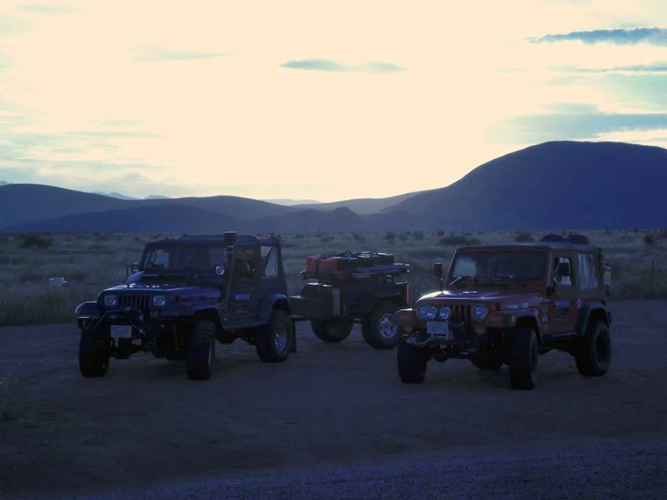
The Shadow of the Rockies adventure would take place in four phases. This was dictated by our start point in Nebraska and the fact we were picking up Alex, a new team member in Montana enroute. We knew our travel time to the start point on the Montana/Canada border would be a minimum two day trek on interstates and highways. Phase One ended up being a four day trip to the Canadian border when it was all said and done. We originally planned to camp near the Platte River in vicinity of Guernsey, Wyoming, but we ended up camped in a city park at Douglas, Wyoming since we made better time than expected on “Day Minus 4.” We continued north Day minus 3 on I-25 to have a wonderful layover with friends in Billings, Montana where we added Alex to the crew and picked up a few last minute pieces of gear.
CDR – Beginning the Journey
CDR – Beginning the Journey
Beginning the Journey
We pushed hard over the final stretches of paved road to our start point on the upper Flathead River at the Canadian border from our final logistics stop in Billings. Due to the late hour on “Day minus 2”, we decided to camp at Seeley Lake south of Kalispell before the final push to the border. When we arrived at the defunct U.S./Canada border crossing the next afternoon where we were surprised to meet Ralph and Sue, a retired Canadian overlanding couple. They were traveling in a well-equipped Ford Super Duty carrying an impressive slide-in camper from the north end of the overgrown Canadian forest road which was the extension of our road. It was an encouraging short conversation since the sun was setting, and we shook hands over the border before parting ways.
We conducted a quick search of the border area and claimed the first of many glorious campsites on a sandbar in the Flathead River literally a stone’s throw from the Canada border down a river access point. We may or may not have invaded Canada for firewood that evening… As the sun sank down behind the mountains, we broke out the field kitchen and started cooking our first meal of Phase 2 of the CDR. The delicious pressure cooker chicken en adobo recipe taken from Overland Journal didn’t last long. A fireside nightcap and fine cigars topped off the evening in what would become our nightly ritual. It finally felt like we were really doing this amazing adventure. None of us had ever spent as much time on an overland adventure as we were now embarking upon, and spirits were high as we attempted to get some sleep.
CDR – Day 1
CDR – Day 1
Day 1
The partly cloudy and chilly morning of “Day 1, Phase 2” broke and we were excited to get going. After a light breakfast, we cleaned up and began breaking camp. While the crew was packing gear and preparing our vehicles, I was struggling loading our GPS routing. Although we used the Big Dogs motorcycle route as the basis for the Shadow of the Rockies journey, there was a significant amount of alternate routing that was to take us through some more technical terrain than the dual sport motorcycles had traversed. These routes had been carefully planned and loaded into the Garmin software months prior, and had required hundreds of hours of research and computer time. Frustratingly, these routes were failing to load properly into the Garmin unit. A truncated version to get us through the first day finally uploaded to the GPSmap276C and we staged the Jeeps for REDCON 1 status. We were behind on our imaginary schedule, but after a quick radio check, we were on our way to the greatest overland adventure for us yet.
Much of the Montana portion of our route would take us on county roads near the base of the mountains, and quite a few of the forest roads we had planned to travel turned out to be gated and locked to vehicle travel. This was a disappointing trend throughout northern Montana. We assessed this was likely due to the proximity to the high volume tourist areas of Flathead Lake and Glacier National Park. Still, we were able to get up into the mountains near enough to the Continental Divide. Mostly due to our late start that morning and the routing issues throwing us off the plan, we didn’t get far on Day 1 and decided to camp in an established campground near Clearwater Lake. We weren’t completely happy with this situation as we always try to camp in remote and unimproved areas, but it was quite beautiful. Fortunately, it would be the only time we had to settle for a populated camp. The lake was simply spectacular in the twilight and was as smooth as glass. Everyone took time out to snap some photos during magic hour on the edge of the mirror lake.
CDR – Day 2
CDR – Day 2
Day 2
Day 2 would bring us more adjustments to our plan. After leaving the lake in the morning, we headed back south on our route, primarily using our paper maps and atlases to maintain the track. The rear suspension on Big Blue was beginning to settle to a lower position than I was comfortable with, so we decided to detour early to Missoula to visit the Montana offices of American Expedition Vehicles. AEV was in the process of moving their shop further into town, so we finally found them and had a great visit. The thoughtfulness and quality of what this company does is amazing and refreshing. They suggested we see the folks at the Missoula Inland Truck Parts to rectify the suspension issue with the YJ. This particular issue was disconcerting since this was certainly not the first time the YJ had completed technical overland journeys in its current configuration. The spring technicians at Missoula ITP submitted that age had finally caught up on the compliant lift springs and simply added an extra helper leaf to rectify the problem for the duration of the Shadow of the Rockies. The great folks at ITP took on the project in the afternoon and got it complete by close of business. Bravo to Ken, Forrest, and Randy. An amazing steak dinner at the Montana Club on Reserve Street finished off the night.
CDR – Day 3
CDR – Day 3
Day 3
Day 3 south out of Missoula would be a lot of pavement, but would end up with our first winch extraction and a little high country adventure. The GPS routing continued to be difficult and we relied on our maps, but the intricacies of unmarked trails combined with a desire to hit backcountry trails led us off of our planned course. The hills and mountains along the Montana/Idaho border are fairly easy to traverse, but the surfaces can be very loose and steep. This is the situation that stopped us on a steep climb. The hill could have been scaled fairly easily, however, the YJ pulling the trailer struggled when momentum was lost and promptly dug into the loose surface. In retrospect, lowering tire pressures and a measured amount of speed would have made the difference on this particular climb. This situation did allow for our first real field use of the Pull-Pal anchor, and it was the perfect tool for the job as the hill was denuded and lacking any anchor points.
The Pull-Pal is an amazing tool, and should be in any winch owning overlander’s kit. Utilizing the Pull-Pal, we were able to easily winch the YJ up the hill to a safe point from which the trailer was also recovered. Tom had no trouble tackling the hill in his TJ once he aired down his tires and got a run at the slope. In short order, we were on top of the ridgeline. This spectacular viewpoint revealed that we were much farther south than the planned route, but we were still near the continental divide, and decided to take our adventure further south on unknown trails. Finding our route along the ridgelines was a challenge on ranch roads, but also provided some amazing views of southern Montana and northern Idaho. Unfortunately, the sun was setting fast, and we were far from finding a good campsite. With clouds and high winds upon us, we thought it unwise to camp up on the exposed ridges, and decided to continue to lower elevations. Before finally dropping back down into the adjoining valley, we drove on the continental divide evidenced by the CDT signs spotted along the trail.
As the sun sank in the west, we aired our tires back to road pressure and reconnected suspension articulation points. Turns out our mountaintop foray on the border of Idaho brought us in a big circle back to within 10 miles of where we started earlier that afternoon. It was another twenty miles or so before we found a creek side campsite just off the road. It turned into a long night around the campfire after dinner, but was cathartic for all of us that were veterans to verbally release some experiences with one another. Matt Hunt is a veteran of Iraq and Afghanistan. Tom was in naval aviation during the Vietnam era, and I had just come off of my first deployment to Afghanistan. It was a lot of joking and war stories, but also ended on an emotional note working through things never spoken of before. The understanding between us was built on experiences only veterans can share. Alex listened to the good and bad of it, and still showed interest in serving himself. After the CDR was finished Alex decided to serve himself and enlisted. He now serves with the Montana Army National Guard.
CDR – Day 4
CDR – Day 4
Day 4
It was a late start for Day 4 due to the equally late night before, but we packed up fairly efficiently and got on the road again. Half of the day would be on pavement or improved county roads in Idaho farmland that led us to the western entrance to the Grand Tetons by way of the Ashton-Flagg Ranch Road. We stopped along the shores of Jackson Lake in the park to take some photos and soak in the glory of the Tetons for a few minutes. It was spectacular country for certain, but absolutely filled with tourists and vehicles. Highway 287 was undergoing some significant construction, so our progress back to some backcountry was slowed significantly. A large group of dual sport motorcycles, most of them BMWs passed by us heading west. We can only surmise they were also riding on at least a portion of the CDR, and brought a smile to our faces. Our first grizzly bear sighting of the trip was on Highway 287 east out of the Tetons. There were plenty of tourists stopped along the road to take pictures, but we carried on. We didn’t realize it yet, but Day 4 it was going to be a much longer day on the road than we had experienced yet.
After leaving the Tetons, we stopped to have a restaurant meal with the intention of just efficiently setting camp once we left pavement into the Bridger National Forest. It was a welcome pit stop for food, fuel, and unwinding. Our pit stop took a little longer than anticipated, but we weren’t concerned since we planned to set up camp very soon and just get some sleep. Initially, the temperature was mild as we gained altitude, but became quite cold up in the alpine flats. In spite of the wonderful scenery and marshlands, there were few viable campsites as the sun went down on us with a blaze of oranges and purples. Those campsites we did find turned out to be occupied. Route-finding on the crisscrossing forest roads was not easy the further we got into the mountains, and terrain association in the waning light was becoming very challenging. This resulted in some unintended detours. That’s all part of the overland adventure, though.
We decided over the VHF radios to continue south out of the mountains to lower elevations and warmer temperatures to camp. We made our way down the valley, but campsites simply didn’t present themselves despite some side expirations in the dark. We decided to take a side trail up to a forested area in the hills where our maps indicated there were campsites, and the terrain was technical enough to be interesting for a four wheel drive, but still no unoccupied suitable campsites for our group. It was getting late now, and a couple of us were now experiencing some gastronomic unpleasantness from our earlier restaurant pit stop. Perhaps, instead, it was the gas station burritos from a pit stop in the Tetons? Never the less, none of us were “happy campers” at this point, but we decided to continue south and east to an area with lakes near some towns shown in the atlas. At one point, we even contacted Alex’s grandparents to arrange an R&R stop at their mountain home, but they were out of town.
We figured it was another hour drive to the lakes, at least. Once we reached pavement south of the Wind River Range, we started making up time, but it was now after 11 o’clock at night. We were surprised and elated to catch a view of a pair of wolves up on the side of the hill next to the road as we sped past. Once at Pinedale, Wyoming, we expected a detour of only a couple miles off the main route to Little Half Moon Lake where we finally decided to camp. Unfortunately, the detour to the lake ended up being almost ten miles with over half of that across dusty unimproved trails. We were finally rewarded with a quiet and secluded waterside campsite after backtracking on the trail. Little more was done this night besides setting up the tents and going to straight to sleep. We were all exhausted from a long day across two states. Matt Hunt was still having some digestion issues, and even spent some time in the cold lake to soothe the issue in the small hours of the morning. The rest of the crew found that tidbit out in the morning since no one really heard his late night foray after falling asleep exhausted. The morning of Day 5 broke to heavy frost on the tents and some still tired overlanders.
CDR – Day 5
CDR – Day 5
Day 5
After reviewing our planned route in the morning, we discovered that we had a lot of terrain to cover Day 5. The mitigating factor was that another vehicle crew was going to be joining us late in the day. The challenge there was that Marcus and his crew were planning on meeting us much farther south than we currently were. Day 5 was to take us across the Great Divide Basin from the shadow of the Bridger Wilderness. After topping off our fuel reserves along Highway 191, we headed to the dirt roads. The county roads there were wide and allowed good speeds to cover lots of ground and make up time. The first surprise encounter of the day was a “traffic jam” herd of cattle being driven down the road by cowboys on ATVs. The Flatwater crew just stopped our vehicles and shut down for the cattle drive to make its way past us. It was about a half hour pit stop, but it was a great opportunity to talk with the ranchers about the area, their lives, and the weather. As we continued to make our way east towards the Great Divide Basin, we crossed the continental divide yet again and raced several herds of antelope along the winding and windy ridgelines. The running prowess of the “speed goats” is impressive. Another photo op on the Continental Divide couldn’t be resisted, so we stopped before entering the basin for a breather. We even got a chance to drive on a portion of the historical Oregon Trail and view some historical markers.
The Great Divide Basin is a large area only broken by hills on the far horizon and some exploratory drilling. Surprisingly, we didn’t see a lot of cattle. The terrain there is very isotropic and isolating with only short prairie grass growing in clumps. We discovered that this is not likely a place you would want to be in an overland vehicle after a thunderstorm. The hard packed soil was great to drive on dry, but a few wet spots around an errant spring proved that the soil in the Basin was mostly clay and of the consistency of bearing grease when saturated. The Great Divide Basin only took a few hours to cross, but seemed to go on forever. The plan was to camp that night in southern Wyoming at a lake and meet up with our third crew. We decided it would be easier to meet at a hotel near the interstate in Rawlins. We were able to happily meet up with Marcus, Rob, and Ben later that night in Rawlins, and we even decided to stay at the hotel and get a real, hot shower before embarking on the next section of the CDR.
That night at the hotel, all the others were relaxing and enjoying themselves while I was bent over a laptop trying to get the GPS routing files fixed and loaded. It simply wasn’t working, and I was getting frustrated at a loss of tens of hours of work. At one point, Matt Hunt came in the room with a tasty beverage for me and remarked that I was still acting like I was in Afghanistan. I was hunched over a computer working on operational products and trying to make plans work when everyone else was living life. He was absolutely right. I wasn’t really enjoying the trip like I should be. I was completely caught up in trying to make everything fit my expectations for everyone involved. It was hard to hear, but right on. I’d like to say that I made a change in attitude and expectations that night, but it just didn’t happen. It would take another week on the trail and the Grumpy Gringo’s veranda in Tubac, Arizona for that to happen.
CDR – Day 6
CDR – Day 6
Day 6
Day 6 was exciting since we finally had the whole team with us. We completed our daily vehicle inspections, loaded our kit, I uploaded some GPS tracks, and we topped off with fuel. After a “REDCON1” call over the radio with the expanded crew, we were on our way south towards Colorado. After a few miles on asphalt, we hit the dirt again. The game of the morning was calling out wildlife within view. It denigrated into a form of “slug-bug” over the radio. We crossed the continental divide yet again before a half hour had gone by, and we stopped so some photos could be taken. This would be the first Divide crossing for Marcus, Rob, and Ben. Having them along would prove to be a great addition, and made the journey so much more enjoyable. They brought along some nice SLR cameras and a lot of fun attitude. The terrain swept by and filled us with a lot of anticipation for the remainder of the trip. We passed through high meadows, historic cabin ruins, and eye-catching aspen boles. Many photo stops were made. Today we also began to refer to cattle in the high meadows and forests as “forest cows”. However, the phrase must always be spoken in a whisper (even over the radio) when they are encountered so they would not be disturbed into wrath! “Forest cows” became one of our running jokes for the entire journey.
Halfway through our day and in northern Colorado, we passed through some forest and high prairie to find a fence and threatening signs on the forest road leading down to the valley. We stopped and consulted our atlases to make sure we were still on public land and hadn’t strayed off course. Every map we had showed us to be on Forest or BLM land. Small plots of private land within public land is not uncommon along forest roads in the western states, however it is generally not legal for landowners to block access to public land along established routes. We were convinced we were on the right path and continued on the forest road. Of course, we closed every gate we came upon and pressed on to the county road. The forest road spilled out in a cluster of ranch buildings about a hundred yards from the county road. As we were passing through, an extremely irritated woman came rushing up to our convoy and demanded to know why we were trespassing and had ignored the signs. There was a long conversation that ensued, with much threatening of lawsuits and such by the woman. I pulled out my maps and GPS and politely asked if she could confirm where we were. I pointed out the forest road and the county road on the maps and confirmed with the GPSmap276C. She immediately changed her tune and pointed down the driveway and said “that’s the county road”. We thanked her for her assistance and continued on our way.
The whole exchange was irritating to say the least, but as I thought about it more, it truly angered me. The landowners were purposefully attempting to block public right of way and access to public lands. I suppose that just coming off of a military deployment compounded my disgust for the whole situation. I will concede the landowners may have experienced harassment by people driving vehicles at speed near their home and outbuildings, leaving gates open, and the like in the past. Nothing happens in a vacuum or without cause, but it still tremendously upset me. We would soon come across another similar situation further south into Colorado, but there was a reasonable and commonplace sign stating that the traveler was crossing private land and to not stray from the road and close gates. This is the norm for most backcountry roads and trails that cross private plots. Still, I would encourage bypassing this area in northern Colorado to avoid unnecessary unpleasantness on an otherwise uplifting journey.
We drove on just a little further on the county road before coming upon a Forest Service campsite. It was established, for certain, but not very occupied, so we decided to make our nightly stop before we burned too much daylight. The motivator for this was that after our little run-in up the road, we found lots of properties blocking roads and closed campsites. It seems that this area is a hotbed of privatizing the Rockies.
CDR – Day 7
CDR – Day 7
Day 7
We made excellent time and distance Day 7 through the lakes, valleys, and roads of northern Colorado and met our goal of camping on upper Tiger Road east of Breckenridge. This particular spot is a favorite camping area whenever the Flatwater Overland crew is passing through the area. We have stopped here overnight many times on our way to Utah or other parts of Colorado, and each camp there is refreshing. With three trucks, our typical spot along the creek simply didn’t have the space, so we had to trek a little farther up the mountain for a larger spot. We were excited for this campsite since it was secluded and near a rushing mountain creek. This would also be the first conception of the “epic fire pit”. We assigned different logistics tasks amongst ourselves as planned and went to work setting up the campsite, gathering firewood, and preparing the evening meal. Preparations went smoothly and we were quickly enjoying our meal around a roaring campfire and discussing the day’s events.
CDR – Day 8
CDR – Day 8
Day 8
Day 8 would prove to be eventful and the first of several consecutive days where we didn’t get below 6000 feet MSL elevation. The primary goal for the journey this day was to scale Mosquito Pass with the convoy. Mosquito Pass has the distinction of being the highest backcountry pass trail that can be crossed in a motor vehicle in the lower 48 states. It is a popular destination for technical trail driving in Colorado since it connects the popular South Park Valley to Leadville. The trail itself is often steep and rocky. If snow does not block the trail, it can usually be traversed by any experienced 4x4 operator with a near stock truck. The Mosquito Pass Trail rates a Class 6 on the Flatwater Overland 4x4 Trails Rating Chart. This class rating is primarily due to grades encountered on the west side of the pass and erosion on the switchbacks. The crew took plenty of photos on the ascent, and it was one of the eroded switchbacks on the west stide that caused an issue. We came down one switchback just a little too quickly and bounced one side of the trailer axle into a hole.
The combination of the steep down grade and dropping into the washout tipped the trailer onto its top. The Adventure Trailers Max Coupler allowed the trailer to roll without functional damage the Jeep or the trailer. We inspected the situation and came up with a plan to right the trailer. It was light enough, so I decided to finish rolling it downhill onto its tires. In this instance, I should have listened to my crew and winched it uphill back onto its wheels. Continuing the roll ended up damaging the light duty aluminum rack mounted to the top of the trailer which held the Pelican 1650 cases. The trailer itself and the Pelican cases were unharmed, but the rack was bent and the plastic chainsaw case was damaged. The trailer was hitched back up to the YJ and we continued down the mountain to Leadville.
After we attempted some cosmetic repairs to the aluminum trailer rack in Leadville, and assessed for any additional damage, we continued south on US 24 to Buena Vista. From there it was west again over Cottonwood pass towards Taylor Park Reservoir. We swung back around the mountains towards historic Tincup to find our campsite for the night. We found a great site just off the trail at the location of an old mine. Rob, Marcus, and Matt refined their “epic fire pit” skills while Alex focused on firewood collection and cutting. Unfortunately, we discovered that the old chainsaw we carried was damaged in the rollover and required some repair. It was barely functional due to a bent bar, but we at least got a large log blocked up enough to hand split it. That night would be good sleeping after a pot of stew.
CDR – Day 9
CDR – Day 9
Day 9
Day 9 would prove to be eventful and challenging as well. After breaking camp and heading over Cumberland Pass towards Pitkin, we continued our journey south. Our route took us through some ranchland by way of improved roads that allowed us to make good time to Cochetopa Pass. We continued south and east towards Del Norte across the wide valley floor. The terrain became undulating enough to warrant more axle articulation, so we disconnected our sway bars and aired down our tires before heading across the valley floor. There had been some heavy rains and flash flooding in the recent past, so some of the trail still held large water puddles and evidence of piled natural debris. The convoy spread out as we stopped at different points to take photographs, so we made a stop under East Butte overlooking the Rio Grande river valley. As Marcus pulled up, a mechanical rattling from his front axle was evident.
We knew something was not copasetic, and the axle U-joint was visibly loose, so we slowly made our way into Del Norte. Fortunately, there was a well-stocked NAPA in Del Norte that would have everything we needed to get Marcus’s ZJ repaired. After removing the front wheel, we discovered that one of the brake caliper bolts had broken free, and the other was loose. One of the threaded holes was damaged and required rethreading. Fortunately, the NAPA also had a correct CV front axle half-shaft to replace the current axle shafts that had been damaged to the point of not being able to replace the universal joint. The repairs were a two hour operation that went right up to NAPA’s closing time, but we fortunately carried sufficient tools to completely repair the damaged axle and brake. This was a good lesson for us all on the importance of thorough maintenance inspections. No amount of capability in an overland vehicle will overshadow reliability.
After fueling all the vehicles, we were anxious to arrive at a spectacular campsite high in the mountains. We headed south out of Del Norte towards Indiana Pass and Summitville. Indiana Pass next to Greyback Mountain is an awesome view in every direction. The elevation here is roughly 11,500 feet. Weather had been moving in, and clouds were forming around us and we drove in mist. We continued on a few miles to Summitville, a mining ghost town and an EPA Superfund cleanup site. We decided to go a little further over the mountains to a valley cradling De Nolda and Annella Lakes. The lakes were mirror smooth and basically required us to take some quality photographs. There were other campers in the valley, but we found perhaps our favorite campsite of the trip in a meadow next to a creek and waterfall. Dry firewood was not in abundance, and required some hard work out of Alex. Especially since the old chainsaw was now struggling to operate. Matt, Marcus, and Rob had the “epic fire pit” construction down to an art. However, as soon as we arrived and began to unload the vehicles, Tom realized he had left his cell phone in Del Norte and had to drive back to town to retrieve it.
We told Tom to stay in contact on the radio as long as he could, because there was no cell service where we were camped. It took quite a while to get dinner made and the camp set up since we decided on stew once more, and we made it from scratch. We also reset the campsite configuration and set up tarps in case the rain began in earnest. With a water source close by, and several days on the trail, it was time for a shower. Everyone lined up for a chance with the YJ’s onboard hot shower system. Between everyone jockeying for the next turn and portaging buckets of water to the YJ to run through the system, the whole process became quite comical. It had become downright chilly after the sun set and we huddled around the campfire after a shower. Matt broke out his laptop and we watched a movie, silently hoping Tom’s call sign would come loud and clear across the radio. The hour got late, and we still hadn’t heard from Tom. Matt and I became concerned and decided we had better go look for him.
Our HAM radios were double checked, the trailer was unhitched from the YJ and Matt and I set forth on a rescue mission. We continued to do regular radio checks with Marcus at camp and called out to Tom. We got out of range of camp being able to transmit to us, but only a couple minutes more and we heard Tom shout out his call sign! We breathed a sigh of relief and began coordinating to determine where Tom was and how to meet up with him. We finally met up at Summitville and headed back to camp. We learned some valuable lessons in this situation. First, we did not have comprehensive communication plan in place before Tom left. Second, we didn’t implement our APRS navigation radios properly to the situation. Both of these learning points were applied to the Flatwater Overland SOP for future journeys. This situation also showed us once again the power of HAM radio in overland travel. We also later determined that Tom was 30-40 miles away when we first contacted him, and Marcus was able to monitor every transmission between Tom and our mobile radio at base camp.
CDR – Day 10
CDR – Day 10
Day 10
The dawning of Day 10 was gorgeous and we were excited to cross into New Mexico even though we lamented leaving the amazing high valley camp. We passed by the beautiful lakes once again and headed down the valley towards Red Mountain. Our route took us south to Platoro and further on towards highway 17. I had heard a squeaking noise coming from the engine compartment of the YJ, and since it was a brand-new engine, I was paranoid something might be amiss. I convinced the Flatwater crew to detour over to Chama, New Mexico for a quick inspection. My concerns were unfounded as it turned out the squeaking was only the serpentine belt. A little bar soap rubbed on the belt quieted it down. We stayed for lunch in Chama at a coffee shop, refueled, and washed off excessive mud from the mountains before we travelled too far and possibly took noxious weed seeds with us. Tom especially enjoyed Chama since it was a historical railroad town and featured a functioning steam locomotive.
The backcountry trails became more technical as we headed back into the forest and required us to air down the tires and disconnect the sway bars again. The obstacles we encountered were limited to washouts and loose rocks that shouldn’t concern a typical overland vehicle. One washout in particular required us to initiate some trail building. Fortunately, all of our Jeeps are capable of traversing quite technical terrain, so it only took a little shovel work to cross the washout. The trail took us along the western border of the Cruces Basin Wilderness area. The meadows along the ridgeline here were gorgeous, and a large mud puddle beckoned Marcus to do a high speed pass and create a wall of mud and water with his Grand Cherokee. It was starting to get late, and we wanted to stop early enough to set up camp in the daylight and enjoy the evening around the campfire.
We started looking for a campsite once we got back into the forest. This high stand of spruce had taken a beating in some winter storms. The trees were all broken in some manner and branches of various sizes littered the ground. In the late afternoon light, it made the forest downright spooky. Matt suggested that this would be a poor area to camp due to the very real possibility of falling branches causing injury or damage to the vehicles. We only had to travel another half mile before finding a fine campsite in a clearing with a dilapidated fire ring. We immediately settled into our individual tasks and set up camp. Thankfully, there was plenty of firewood available for the now heavily modified “epic fire pit”. This turned out to be a good thing, because half of our party decided to, well, party most the night. The forest cows left us alone but were never too far away and eternally curious.
CDR – Day 11
CDR – Day 11
Day 11
Most of Day 11 was spent in the New Mexico high country chasing isolated thunderstorms and the forest cows. From the first trial runs on the CDR several years ago, New Mexico never disappoints if you are looking for remote backcountry. In this respect, it’s much more satisfying than populated Colorado. The topography in this section of the Shadow of the Rockies is always changing and made more fascinating by the diverse weather patterns. Summer was barely hanging on when we passed through, and the monsoon storms common in the desert southwest were pushing their influence this far north. We continued south and down into El Rito and then to Abiquiu where we picked up some supplies for dinner that night. I always like stopping in Abiquiu. The area sits in a river valley and is heavily influenced with Spanish and Native culture. The general store/gas station is a perfect place to top off on provisions before heading south towards the Valles Caldera escarpment.
After climbing out of the river valley and onto the plateaus, the views are wide and impressive with low grass and scrub stretching out to the distant foothills. The CDR route took us on top of an ancient volcanic ash flow and we followed it south, constantly gaining elevation. In an absence of rain, the trail on the ash flows can harbor long sections of volcanic moon dust that is absolutely destructive to vehicles. My last experience here made me thankful for the snorkel. Recent rains in the area on this crossing made the surfaces stable, so the dust was not an issue, and there were even some wildflowers in bloom. Once we were high on ash flow where the pines were growing, we stopped for some photos of the canyons and buttes. This would be an excellent area to stop and spend more time in photography.
We continued on to the higher reaches and meadows of the mountains that make up the outer rim of the Valles Caldera. We pitched camp in the waning light on the edge of a high meadow under huge pines. There was a herd of cattle grazing out in the meadow next to a marsh as a cumulonimbus storm cloud grew high into the atmosphere and became illuminated from within by lightning. There was plenty of wood for the night fire, but much of it was rotten punk wood. This would be the last use of the old chainsaw before it gave up the ghost. The rest of the firewood was cut with bow saws and split with a maul we always carry. The “epic fire pit” tonight was the most epic of them all. It sported a wide stone ring, four air feed trenches underneath, and plenty of burn depth. The thunderstorms moved off as night fell, and we attempted some long exposure photography of the sky and camp before the batteries in the cameras gave out.
CDR – Day 12
CDR – Day 12
Day 12
It rained overnight, and the morning of Day 12 on the trail started a bit wet. The Shadow of the Rockies route today would take us along the periphery of the Valles Caldera through high, misty forests. The route required some technical driving from time to time, but the rest was on well-maintained forest roads. Some remote sections even allowed for a bit of rallying with the Jeeps. The day passed quickly as we crossed the mountains towards the next patch of pavement down into Cuba, New Mexico. This would be the last day Marcus and his team would be with us, so we wanted to do a nice going away lunch at a restaurant before they began the long trek back to Nebraska. Tom, Matt, Alex, and I decided to locate a hotel for us to get some good sleep and wash clothes that night before the final days through remote backcountry to the Mexican border.
First on the list after fueling the vehicles was a fine meal of Mexican food. Perhaps the best Mexican restaurant we have ever eaten at is in Cuba. El Bruno’s was amazing. They made fresh guacamole at the table, and as Marcus stated, “The best margaritas, EVER!” We tried to weasel the recipe out of them to no avail. The food was so good, we informed the waiter we would be back for dinner. We weren’t kidding, either. After a long lunch, we sadly parted ways with Marcus, Rob, and Ben and proceeded to occupy our hotel rooms for the night. There was much still to do as we needed a new chainsaw, clothes needed washed, the GPS needed updating, and maintenance checks were due. There was no way we were going to miss another meal at El Bruno’s, though! I’m still not sure why the owner was surprised to see us again.
CDR – Day 13
CDR – Day 13
Day 13
Day 13 began chilly and shrouded in clouds. More rain had fallen overnight down here in the lower desert. There was concern among us that the rains would make the desert trails we were heading for impassable. We did encounter some soft spots on the maintained roads, but once on the ranch trails, they were mostly sandy soil or rocks. This became entertaining overland travel since the dissected terrain made for some interesting trails that wove in and out of arroyos and around rocks. Finally, we came upon some major drainage arroyos where there were recently deposited shelves of mud and sand on each trail approach to the wash. These were obviously deposited by flash floods overnight and were solid enough to walk on, but quickly turned to quicksand once driven over with large tires. Thankfully, on two separate occasions, neither of our vehicles became mired even though it took judicious throttle use to make it through the sandy goo.
There were many opportunities for photos in this stretch of the route and historic sites, but we still made good time across the desert. Radio traffic was heavy on the southwest repeater network, and we got updates about weather from all across the region. We also learned that the Pie Town pie festival was underway that very day. We planned to pass through Pie Town that evening before camping, so we were hoping to partake in some of the renowned, but small festival. As we continued south, some massive thunderstorms exploded into the atmosphere along our route. This was exiting to Matt, who has a B.S. in meteorology, and remains passionate about weather studies. We made a pit stop in Grants to wash excessive mud off the Jeeps before travelling further and to top off our fuel tanks and fuel cans. The next stretch of the CDR would be roughly 270 miles before we would be able to fuel up again.
South out of Grants, we paralleled the lava flows of the Malpais National Monument and the cliffs of The Narrows. These huge lava flows feed the imagination to a time when massive volcanos changed the landscape of New Mexico. This would be a place to visit once again and do some hiking and photography. We had just missed some very powerful thunderstorms, and the roads were still filled with standing water puddles. We turned off of 117 and headed south to Pie Town on dirt, once again. The storms had softened much of the road, and we came upon several massive mud holes. One was a couple hundred meters long and had a long bypass around it. Tom missed our tracks going wide around the hole, and got his TJ stuck in some very greasy clay. We winched him out easily, but his mud packed all-terrain tires made it difficult to escape the ruts. Pie Town wasn’t far now.
Disappointingly, the Pie Festival was already over. Apparently, it was closed early due to weather. Every campsite near Pie Town was taken as well. That left us little choice but to head further south in the waning light. Day 12 would turn out to be another long one in our never-ending quest for the perfect campsite. The terrain just south of Pie Town is wonderful with cedars, and small volcanic cones. The county roads here wind around the hills and trees and through dry washes running water from the recent rains. This coupled with the setting sun filtered through breaking clouds and low hanging vapor clouds made it all the more special. I would say it was almost mystical as the sunlight turned orange and purple right at sunset. We kept an eye out for potential campsites, and Alex studied the atlas for possible official sites along the route. Several stops and short recons after dark yielded nothing close to the road we wanted to stay at. We finally did pitch camp in the very north end of the Gila National Forest.
CDR – Day 14
CDR – Day 14
Day 14
Overnight, more storms rolled through, and rained on our camp. We woke on Day 14 to ranchers attempting to drive their trucks and horse trailers up the muddy forest road without success. One, who actually leased the forest land here for his cattle parked his trailer and unloaded the horses in order to check his cattle. He brought to our attention the fact that there was an introduced pack of Mexican wolves in the area. A couple had even left paw prints in the mud around our camp during the night. We were disappointed that we missed seeing them or hearing any howls. We waited out the morning with several cups of coffee, hoping the roads would dry up some. The roads stabilized, but quickly turned slick once tires began to turn on them.
Our very first section was going to be mud and up a 20% grade with little room to gain momentum. The hill was also so long, that no amount of momentum would carry a vehicle up anyway. The YJ with the trailer didn’t struggle too badly with the aggressive Mickey Thompson tires, differential lockers, and 300 horsepower stroker engine. It did become a challenge to keep the Jeep and trailer on the crown of the road once on top of the hill. The ruts in the road swerved wildly from side to side and were strangely spaced. Tom in his TJ had a tougher time of it due to his lack of differential locks and the all-terrain tires. Tom’s TJ still had factory width fender flares, so the amount of mud his Jeep collected coming up that section of forest road was simply comical. We took a pit stop on a more maintained portion of the road to remove the large mud clods from Tom’s windows so he could see.
The backcountry roads we took to Silver City again led us through beautiful and varied terrain. We passed through old growth pine forests and meadows, rolling grassy ranchland, and finally into narrow rocky canyons lined with pines and flowing with clear streams. This area of New Mexico is laced with 4x4 trails through thousands of acres of amazing backcountry. This would absolutely be a place to come explore and camp. Our fuel situation was not as critical as we thought it might be after this stretch, but we refilled our tanks and cans in Silver City. The mud was dropping off the Jeeps at every seam in the road, so it was again time to remove all the soil so we didn’t drag weed seeds into another area. We were on the home stretch now.
The last part of our journey to the Antelope Wells was on well-maintained ranch roads and some paved two-lane. As we pointed south from Silver City, we tracked over rolling hills covered with grass and cattle. There were always mountains in the background casting shadows across the ranches. As we neared the Mexico border station, the sun was low in the sky and projecting shafts of light eastward. The road was busier with grasshoppers and tarantulas than vehicles. In fact, the only vehicles we did see were the sage green and white Border Patrol trucks. We snapped our obligatory picture at the border gate, and discussed our seventeen days of travel and two years of preparation that brought us to the completion of Phase 2 of our journey. We still planned to cover more ground and camp that night, but security measures along the border region foiled our overlanding plans for the night. We ended up acquiring a hotel room and pushing on to Tubac and The Grumpy Gringo the next morning.